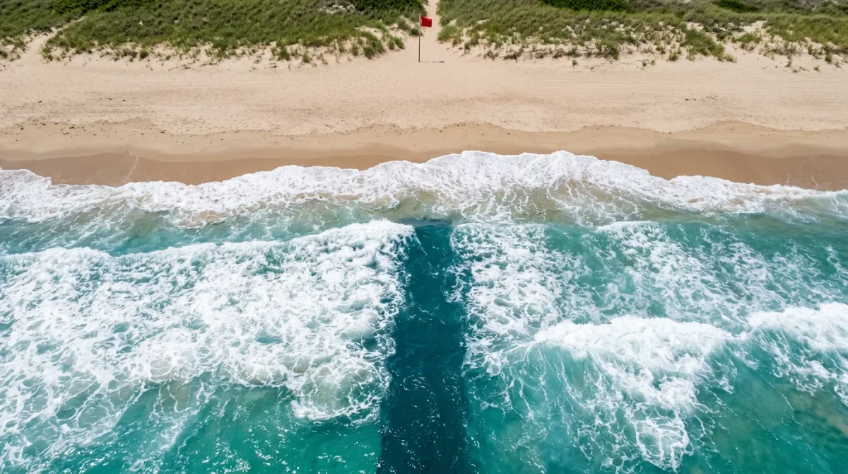
The most useful thing to check before a swim is not the sky but the forecast: the National Weather Service publishes a rip current risk level — low, moderate, or high — for surf beaches, and it is out before anyone reaches the sand. NOAA's satellite and data service puts U.S. rip current drownings at roughly 100 a year.
Rip currents are the quiet hazard of a coastal vacation. They do not announce themselves the way a storm swell does, and the instinct they provoke — swim hard for shore — is the wrong one. What follows is the agency guidance in the order a traveler needs it.
What Is a Rip Current, and How Fast Does It Move?
A rip current is a surface current flowing away from the beach, formed where waves interact with the shape of the ocean floor or break in an uneven pattern near shore, according to NOAA's National Environmental Satellite, Data, and Information Service. Most move at one to two feet per second. The strongest have been measured at eight feet per second — about five miles per hour, quicker than an Olympic sprint swimmer — per the same NOAA explainer on escaping rip currents, which also puts typical rip widths at 50 to 300 feet.
One detail undoes more beach days than any other: the National Weather Service notes that rip currents often form on calm, sunny days. Flat, inviting water is not evidence of a safe swim, and a beach that looked benign yesterday can be running a strong rip this afternoon on the same tide.
How Do You Spot One From the Sand?
NOAA's guidance names two visual signs, both worth a few minutes of watching before anyone gets in. The first is an absence of breaking waves — a gap in the steady line of whitewater. The second is movement offshore: foam, seaweed, or discolored, sandy water sliding away from the beach.
Neither sign is reliable enough to stake a swim on. The National Weather Service is blunt that rip currents are difficult to see, which is why the posted forecast and a lifeguard's read of the water outrank a visitor's own. Its Wilmington, North Carolina, office adds that even on a low-risk day, dangerous currents can form near structures such as groins and jetties — so a rock jetty or pier is water to avoid whatever the forecast says.
What Do the Posted Risk Levels Actually Mean?
Surf zone forecasts carry a three-step rip current risk. The wording matters, and it is more specific than most travelers assume — these are the National Weather Service's own rip current risk definitions.
| Risk level | What the National Weather Service means by it |
|---|---|
| Low | Surf zone conditions are not expected to support the development of life-threatening rip currents — though dangerous currents can still occur near groins and jetties. |
| Moderate | Surf zone conditions are favorable for the development of life-threatening rip currents. |
| High | Surf zone conditions will likely support the development of life-threatening rip currents. |
Read plainly, "moderate" is not a middling day at the beach; it is the agency saying the ingredients are in place. Check the forecast the morning of — risk levels are reissued, not fixed for the week.
What Are the Beach Flags Telling You?
Flags are set by whoever manages the beach, not by the forecast office, so they answer a different question: what the conditions are right now, on this sand. Much of the Gulf and Southeast coast uses a common color scheme, laid out in the Alabama Department of Public Health's flag guide, published July 19, 2024.
| Flag | Meaning |
|---|---|
| Yellow | Medium hazard — moderate surf and/or currents are present. |
| Red | High hazard — rough conditions such as strong surf and/or currents. |
| Double red | The water is closed to the public. |
| Purple | Marine pests such as jellyfish or stingrays are present. |
| Red over yellow | The area is protected by lifeguards. |
| Quartered red and white | Emergency evacuation — leave the water. |
Local systems vary, so read the beach you are on rather than the one you remember. In Florida's Panhandle, Bay County's beach safety flags page adds a green flag for calm conditions — while noting hazards always exist — and describes double red as water closed because conditions are too dangerous for even the strongest swimmers. The managing authority's page is the place to confirm local flag rules, not a rental listing.
What Should You Do If You Are Caught?
NOAA's instruction is four short clauses: stay afloat, yell for help, swim parallel to the shore, and do not exhaust yourself fighting the current. The National Park Service puts the same idea in sequence in its surf and beach safety guidance for Assateague Island National Seashore — stay calm, swim parallel with the shore a short distance, then angle in toward the beach once you are out of the current. If you cannot reach shore, the Park Service says to float on your back, control your breathing, and signal for help.
The rest of the Park Service's Assateague rules are the unglamorous ones that keep the first set from being needed: a buddy system, constant adult supervision for children, Coast Guard-approved flotation vests for non-swimmers, no water in thunderstorms, and no swimming after drinking.
Does the Beach You Choose Change the Odds?
It changes them more than the forecast does. Citing the U.S. Lifesaving Association, the National Weather Service puts the chance of drowning at a beach with lifeguards at one in 18 million. NOAA's figures also credit lifeguards with roughly 30,000 rip current rescues a year in the United States.
Guarded hours are narrower than most itineraries assume. At Assateague Island National Seashore, the Park Service lists lifeguards on duty Wednesdays through Sundays, 10 a.m. to 5 p.m., in both districts, with swimming outside those hours at your own risk. At Cape Hatteras National Seashore, a Park Service release dated May 21, 2021 listed four lifeguarded accesses — Coquina Beach, Cape Hatteras Lighthouse, Frisco, and Ocracoke — staffed Memorial Day through Labor Day, 9 a.m. to 5 p.m. Confirm the current season's schedule with the park, and plan a May or September trip knowing the towel goes down on an unguarded beach.
The Practical Details
- Beaches referenced: Assateague Island National Seashore (Berlin, Maryland, and Chincoteague, Virginia) and Cape Hatteras National Seashore (Outer Banks, North Carolina).
- Managing authority and rules: National Park Service for both. Buddy system, adult supervision for children, Coast Guard-approved vests for non-swimmers, no swimming in thunderstorms or after drinking, per the Assateague safety page.
- Fees, per the park page last updated February 12, 2026: Assateague Maryland district, $25 per vehicle for seven days, $20 motorcycle, $15 per person aged 16 and over; Virginia district, $10 per vehicle for one day or $25 for seven. The Assateague annual pass is $45.
- Season and typical conditions: guarded swimming is a summer product — Wednesday to Sunday, 10 a.m. to 5 p.m. at Assateague; Memorial Day to Labor Day, 9 a.m. to 5 p.m. at the four Cape Hatteras accesses in the 2021 release.
- Before you go: pull the National Weather Service surf zone or beach forecast for the specific stretch of coast, then read the flags on arrival.
- Conditions change — check the official advisory before you go.
For a related coastal perspective, read How to Read a Rip Current Forecast Before You Swim, According to NOAA and the Flag on the Sand.