Beach renourishment — also called beach nourishment — is the practice of pumping offshore sand onto an eroded beach to rebuild its width, and on any given year it is running somewhere on the US coast: the US Army Corps of Engineers lists active coastal storm-damage-reduction projects across the Atlantic, Gulf, and Pacific coasts, and local governments run smaller fills alongside them. For travelers, the practical stakes are concrete: a renourishment project can close sections of beach, reroute access, run heavy equipment during your stay, and — once finished — hand back a wider, flatter beach than the one that eroded. Checking the project schedule before booking is now as standard as checking the weather.
This guide explains how the process works and what it changes for a visitor. Project schedules and access closures come from the managing authorities — the Corps, state environmental agencies, and local governments — and their posted updates are the only reliable source for a specific beach and date.
How does beach renourishment actually work?
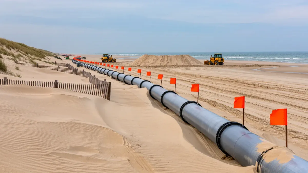
The standard method is hydraulic dredging: a dredge vessel pumps a sand-and-water slurry from an offshore borrow area through a submerged pipeline to the beach, where the sand settles and bulldozers shape it to a designed profile, per USACE project documentation. A second method, truck-hauled sand from upland or inland sources, is common on smaller projects where a dredge is not economical. Projects are engineered to a specific beach profile and width, and the sand is deliberately compatible with the native beach — grain size and color are specified, which is why a completed fill usually looks and feels like the beach it replaced within a season of tides working on it.
Why beaches need it — and why it repeats
Coastal beaches erode when storms, currents, and rising seas remove sand faster than it returns. Renourishment restores the beach and, on Corps projects, is formally designed as storm-damage protection: a wider beach and taller berm absorb wave energy that would otherwise reach dunes, roads, and buildings, per USACE program descriptions. The honest catch is that the sand does not stay put — engineered projects are built with a design life, often measured in years between renourishment cycles, per Corps planning documents. For a traveler this produces the recurring pattern: a beach widens dramatically one year, narrows over several, then the pipes return.
What a project looks like from your beach towel
An active project is not subtle. Expect a dredge offshore on clear days, a pipeline running up the beach — usually marked with lights and flags — an active work zone a few hundred yards to a mile long, and heavy equipment shaping sand from early morning onward, per typical contractor operations plans. Authorities normally keep the beach open alongside the work with a moving construction zone: you set up where the flag line allows, and the zone moves as the pipeline advances. Swimming directly near the outfall is restricted while pumping runs, per posted safety notices. Noise starts early; light-sensitive sleepers should book rooms away from the active segment.
Is the new sand safe to walk on?
Yes, with a few honest caveats the authorities themselves publish. Freshly placed sand is soft and deep — a workout to cross, and strollers and beach carts sink. It can initially contain shell fragments and, briefly, turbid water at the outfall. Sea-turtle-nesting beaches schedule projects around the nesting season, per state wildlife agency permitting, because nesting females and hatchlings need a workable beach profile; the same permits govern lighting and equipment timing. Where a project is running under those permits, you will see the posted conditions — and the wildlife windows are the reason some projects cluster in specific months.
How do you check whether your beach has a project scheduled?
Three sources, in order of usefulness. First, the managing authority: town, county, or state park pages post project notices with maps and access impacts. Second, the US Army Corps of Engineers' district pages list federally authorized coastal projects with current status, per USACE public records. Third, state environmental agencies — Florida's, North Carolina's, and New Jersey's among them — maintain coastal program pages with funded project lists. Search the beach's name plus "renourishment schedule" and trust the .gov results; contractors' and hotels' summaries run behind the official schedule.
Should you cancel a trip during renourishment?
Usually not — adjust instead. The work zone occupies one segment while the rest of the beach stays open, and many projects run in off-peak months precisely to miss the visitor season, per local scheduling practice. Travelers who book during a project should do three things: ask the lodging which segment is active that week and request a room away from it; plan beach time at access points beyond the zone; and keep the refund-and-rebooking terms of the booking visible, since a major storm can reshape any coastal schedule. Conversely, travelers seeking the best sand at the lowest crowd cost sometimes chase the opposite play — the freshly completed fill, which offers the widest beach of its decade in the season after completion.
Renourishment versus what you see naturally
One distinction saves confusion: seasonal beach changes are not renourishment. Beaches naturally widen in summer as gentle waves push sand onshore and narrow in winter as storms pull it to sandbars, per USGS coastal processes research. That cycle reverses itself every spring. Renourishment is the engineered, funded, permitted response to net long-term loss — pipes, permits, and profiles. If the beach looks thinner in March, that is winter; if there is a pipeline on it, that is a project, and the authority's notice will say so by name.